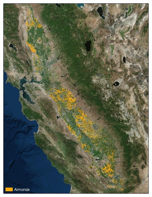
Current, accurate information on constantly evolving almond acreage and crop locations is critical for environmental, market and production applications. Growers, processors, allied industry and others need to understand a variety of factors — tree age, impacts of land use, crop location, acreage, etc. — to best implement efficient management practices that recognize environmental attributes and take into account the impacts of water quality, air quality, disease and/or pest vectors on the crop.
 Land IQ’s initial mapping estimate states that in 2019 there are 1,141,312 acres of bearing almond orchards throughout California.
In response to this need for information, the Almond Board of California (ABC) commissioned Land IQ, a Sacramento-based agricultural and environmental scientific research and consulting firm, to develop a comprehensive, living map of California almonds, orchard by orchard, every two years between 2010 and 2018. The map is the result of nearly a decade of research, and because Land IQ’s approach1 does not rely on surveys or extrapolation, it has an accuracy of 98% or greater.
Land IQ’s initial estimate for bearing acreage takes into account the orchards removed, as well as young orchards coming into production. Based upon this assessment of California almond orchards in 2019, Land IQ determined that there are 1,141,312 almond bearing acres. Further, between the summer of 2018 and the spring of 2019, 37,042 acres were removed and a total of 102,059 acres shifted from non-bearing to bearing.2
Land IQ began an annual mapping process this year, meaning two acreage summaries will be released in 2019: one summary, including the bearing acreage estimate, is being delivered now, in June, and one summary, with bearing and non-bearing estimates for the same production year, will be delivered in December.
“Providing this acreage data on an annual basis brings our work with Land IQ to the next level and allows us to deliver the most accurate information to the almond industry as quickly as this technology allows,” said Almond Board President and CEO Richard Waycott.
Both the Land IQ 2019 initial bearing estimate and a map layer that spatially identifies the orchards removed are available on ABC’s website. Individuals using the 2019 layer on the web map should note that the layer only accounts for bearing acreage; however, some non-bearing orchards that were visually confirmed from ground truthing may also appear.
For more information on the California almond acreage map, visit Almonds.com/Maps. All technical questions can be directed to Land IQ at (916) 265-6358 or technical.support@landiq.com.
[1] Land IQ draws on multiple lines of evidence including agronomic and remote sensing knowledge, unique field boundaries, robust on-the-ground verification, publicly available imagery and other spatial and non-spatial resources.
[2] Land IQ. California Statewide Almond Mapping - 2019. Based on data from USDA National Agricultural Imagery Program (NAIP) and USGS Landsat.